


My apologies to AC/DC or borrowing part of their famous song title for this post. I am a big rock ‘n’ roll fan, and that just popped into my head. You’ll get the meaning in a couple of minutes.
Other than driving up to La Grande, Oregon about a year ago to pick up my new camp trailer, I haven’t been to the Northwest since 2019. It feels like an eternity; for some reason everything that happened prior to Covid almost seems like it occurred in another age.
Anyway, some of you may know that I am an investment advisor in my day job, and this was my first trip to visit my clients in Oregon in three years and the clients I have in Washington in four years. I scheduled in a couple of extra days for some recreation as it’s not like I make it up to this part of the country on a regular basis.

The first night on the road I stayed at a campground in Baker City, Oregon. I planned an extra day there to go exploring. When I was picking up my trailer last year in La Grande, the dealership owner mentioned that the Wallowa Mountains off to the east near the Idaho border were fairly spectacular as was Hells Canyon. With one full day to kick around, I decided that I would make a journey over to Hells Canyon.
For those of you who don’t know, Hells Canyon is a very deep gorge that was created by the Snake River as it flows through the mountains between Oregon and Idaho and eventually into the Columbia River which then flows into the Pacific Ocean. The canyon is about 10 miles wide (16 km) at its widest, and runs from the northern portion of the Oregon/Idaho border up into the border with southern Washington state. It is actually deeper than the Grand Canyon in Arizona.

Hells Canyon’s earliest origins date back about 300 million years ago from volcanic activity around the Pacific Ocean. Sometime between 30 million years ago and 17 million years ago, this area was formed from the collision of the Pacific Plate with the North American Plate. That collision caused more volcanic activity which flooded much of the northwestern United States with incredible amounts of basalt lava. Sometime around 6 million years ago the Snake River began to cut through the terrain and form what is now Hells Canyon – the deepest gorge in North America at 7,993 feet (2,436 m).
When I was searching Google the prior evening figuring out the best route from where I was in Baker City, it looked like I had about a 68 mile (109 km) drive on Oregon 86 over to the canyon. However, as I would soon learn, that 68 miles was only to the beginning of the Hells Canyon area. Even getting to the dam, which is really the beginning of the deeper part of the canyon, was another 32 miles (51.5 km) one way.

But, the journey was well worth it as the scenery was really incredible most of the way. For a good portion of that 68 miles, Oregon Highway 86 follows along the Powder River. The terrain east out of Baker city is mainly a desert type landscape and quite hilly. In fact, only a few miles east of Baker, Highway 86 offers a turnoff into the national Oregon Trail Museum. If you’ve never been there, give yourself several hours. It is definitely well worth the time and very interesting way to get a vision of how difficult the early settlement of the Western United States really was.

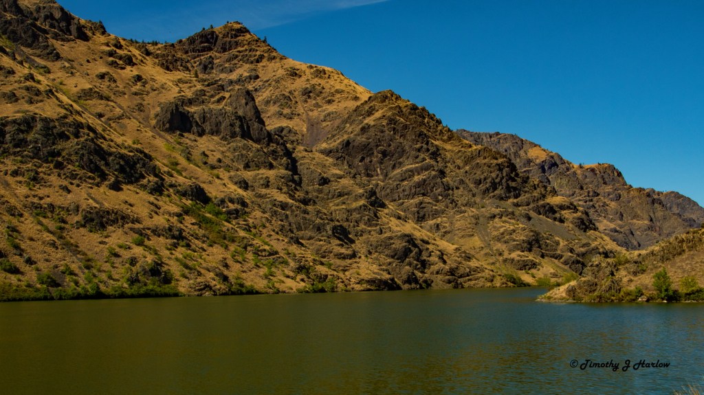
Some of the drive presented some rather dramatic views of the Wallowa Mountains to the north and east. These are incredibly rugged peaks as you can see in these photos. As Oregon 86 proceeded eastward, I eventually got into more farm country, and finally made it to the Snake River near an area known as Oxbow.

Taking this route only allowed me to see the very beginning of the south end of Hells Canyon. Most of the canyon is not accessible by road and is in incredibly remote territory. In fact, the greater Hells Canyon area incorporates over 214,000 acres of wilderness!
Wilderness is a very specific designation given to protected areas in the US which prohibits any type of motorized travel or equipment usage. It is only given to more primitive type areas.

The farms above are east of Richland, OR, one of the bigger towns in the area. Right about the 68 mile point from Baker City, OR 86 stops and a side road crosses the Snake River into Idaho. The sign said it was about 32 miles up this tiny two-lane road to the Hells Canyon Dam. Never having been to the area, I decided to head up to the dam as it looked like the terrain would get more rugged from there.

This road was very narrow, and quite winding with many curves marked at 20 miles per hour to 30 miles per hour (32 kph to about 48 kph). The farther north I got the more interesting the scenery became.
This little road (I think it had a US Forest Service designation) followed the Snake River through the gorge, but it did provide some awesome views as I drove further northward along the river.

Even though this road was only 32 miles, it seemed like it was taking almost as long to reach the dam as it took to reach the Snake River. More curves, more views, and finally, here was the Hells Canyon Dam.
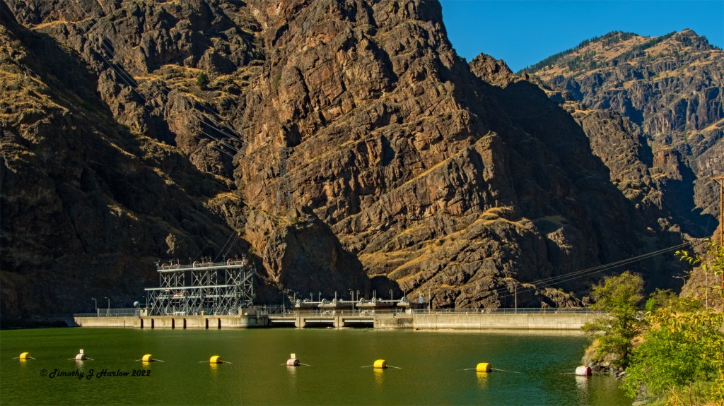
I thought this was going to be the end of my journey, but as I approached the Dam, the road actually crossed the dam back onto the Oregon side. The road went maybe another half mile, and there was an option to descend down to a Visitor’s Center for the Hells Canyon Dam. So I turned down there,and found a very nice, shady parking spot.
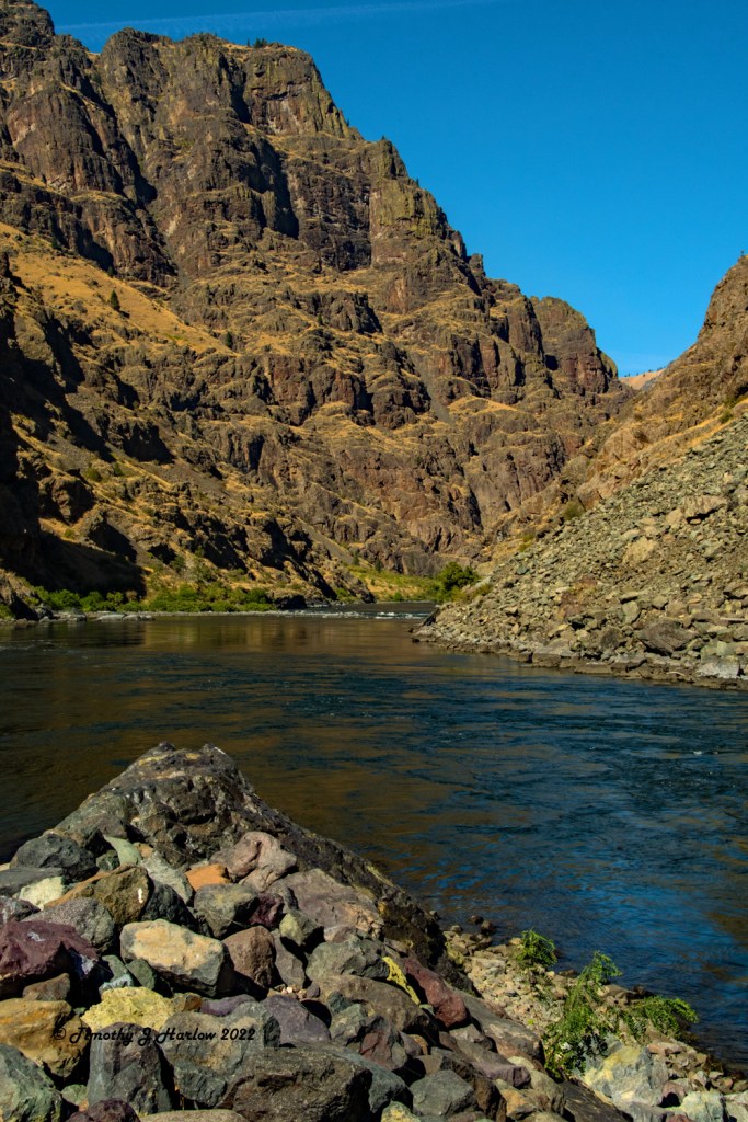
After a quick tour of the Visitor Center, I walked down to the river by a boat launch to get more photos of the actual Snake River, downstream from the dam.

After looking around and taking several photos, I walked back up the long stairs to the Visitor’s Center. I was intending to walk across the parking lot and use the restroom, before heading back to Baker City. However, as I rounded the building toward the front, I caught this guy staring right back my way.

After I went back around the building for cover, I decided to try to get inside from the east side – away from the bear. Once inside I told the reception person that there was a bear outside by the restrooms. She said, “Oh, that’s probably Mr. Bear (I can’t recall what she called him). I will go shew him away.”
Then when she got outside she says, “That’s not Mr. Bear. This one is much bigger. Everyone stay here while I call the rangers!”
The above photo was taken while I was standing next to the reception person with her air horn. I pointed out that those rocks go nowhere. He was stuck between us and the rocks. So she decided to keep us back and not try to scare the poor bear away.
Anyway, after I was able to get back to my truck, I headed back down the river toward the crossing and back to Baker City. To get to my truck I had to walk down the long sidewalk across the road from our bear friend, all the while watching him watch me.

I really like how the monochrome makes the canyon look more dark and mysterious, keeping with the name – Hells Canyon.
This was a very fun day that ended up being way different than I could have imagined. Getting to see such a remote and beautiful area, and then being lucky enough to have my closeup encounter with the bear.
So, I hope you all have enjoyed this story about my experiences in Hell’s Canyon, and hopefully you now get my title.
Thanks so much for visiting my blog, and have a wonderful time out there.


Beautiful country, but you can keep the bear…lol
LikeLiked by 1 person
Thanks! I didn’t bring him home. 😂
LikeLiked by 1 person
Dont blame you, dont think they make good house pets!
LikeLiked by 1 person
Good story and adventure!
LikeLiked by 1 person
Thanks Ben! Hope life is treating you well.
LikeLike
With that scenery, we should all have a hell’s canyon! Our country is magnificent!
LikeLiked by 1 person
It truly is GP! There are so many absolutely incredible places in nearly all the states. Eastern Oregon gets little attention compared to the west coast, but the scenery is equally astounding. Thank you very much for reading.
LikeLiked by 1 person
I’m always here, Time, but rarely have time to comment. Besides everything else going on here, lately I’ve been sleeping late – go figure!! (Just getting old, I suppose.)
LikeLike
Wow these are some great shots – although I think I would have run away from the bear!
LikeLiked by 1 person
Thanks M.B. The only place to run besides into the building was down the parking lot road, and I am not as fast as a young bear. You know what the bears say about us “crunchy on the outside, chewy on the inside.” 😂
LikeLiked by 1 person
LOL!!!
LikeLiked by 1 person