


As I have traveled around our beautiful country I sometimes forget the wonders that are in my own backyard. I grew up in El Paso, Texas where I lived with my parents until the middle of my junior year of high school. At that point my Dad was transferred to Houston, and that is where I finished high school.
El Paso was so named because it lies at the southern end of the Franklin Mountains where they dip down to the Rio Grande River. If you go into Mexico there is another mountain range to the south which also dips down on the north end near the Rio Grande. El Paso was originally named El Paso Del Norte, which meant the pass of the north. It was named by Spanish explorers, and soon became a popular trade route. Spanish explorer, Don Juan de Oñate, may have been one of the first Europeans to see this area. The United States has had a military base in El Paso, Fort Bliss, since the 1850s.
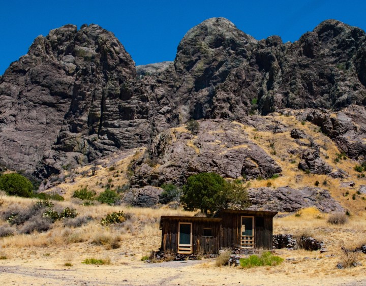
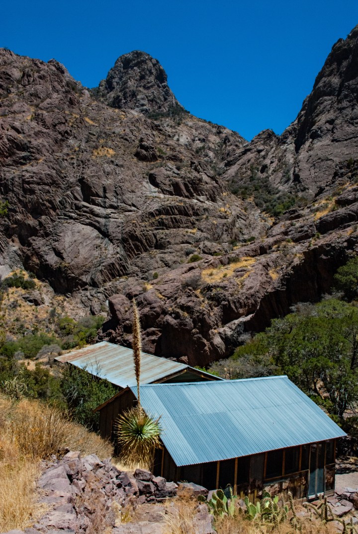
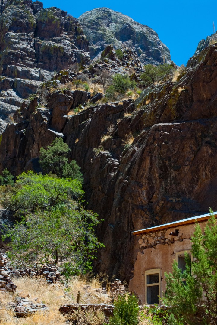
The Organ Mountains run north and south to the east of Las Cruces, New Mexico and come almost to the western tip of Texas. The previously mentioned Franklin Mountains are located slightly to the southeast. The Organ Mountains are very rugged and were named from their resemblance to pipe organs. They are primarily made of igneous rock, thus they can have hues which range from dark gray to almost black and then picking up other colors in different lights such as reds, pinks and lighter grays. The Organ Mountains have a long and varied history, and were popular hiding places for the Mescalero Apache Indians trying to escape from the US soldiers who were often sent out to round them up. Due to the remoteness and the ruggedness, especially on the east side of the range, there are many stories of banditos and other “bad guys” who resided in these mountains in the first half of the 20th century. However, their beauty and ruggedness is quite astounding. It’s a harsh land, with very little water and a lot of heat in the summer. Rainfall in this part of the Southwest averages about 4 to 8 inches per year, usually closer to four.

The last time I was there I took some photographs around an old tuberculosis sanatorium which is mostly in ruins now. There were a few buildings left, which as you will see suggest a rather harsh existence for the folks who were there in the latter part of the 1800s and early 1900s. This desert is part of the Chihuahua Desert. The Chihuahua Desert ranges from north-central Mexico up into west Texas, southern New Mexico and the southeastern part of Arizona. In general this is a higher desert with mountainous terrain. However, the Rio Grande River runs down through the middle of it where it empties into the Gulf of Mexico at the southern tip of Texas.

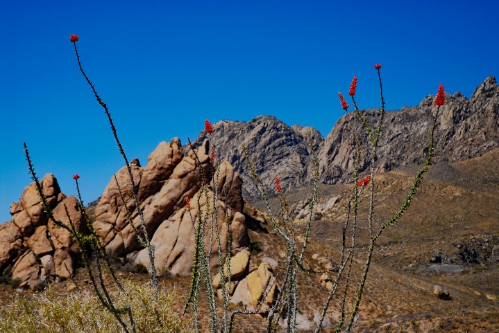
 There are some very interesting plants in this desert such as the yucca cactus which is quite beautiful when it blooms. And if you’re in the desert in the early spring, you might be lucky enough to see some prickly pears in bloom which have beautiful bright flowers that range in color from bright yellow to pink and fuchsia. Honestly, I’m not sure why some of the prickly pears have pinkish flowers and others have yellow. One of the other interesting cacti is the ocotillo. It’s made up of a series of segmented stocks, and if you come at the right time in the spring, they have beautiful, bright red flowers.


As you drive northeast from Las Cruces you cross the northern end of the Organ Mountains and end up on the outskirts of White Sands Missile Range. White Sands Missile Range was crucial in the development of our space program, and to this day it is a highly guarded military installation. As you drive north you’ll eventually come upon White Sands National Monument. As you’re driving towards the monument from the south you see glistening bright sand dunes off to the northwest. If you are coming the other direction (southwest) from the mountains of southern New Mexico as you come down towards Alamogordo, you can see these white sand dunes from nearly 100 miles away as you’re looking towards the west.

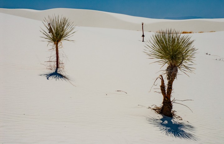
White Sands is completely misnamed. The sand is not sand at all. Rather it is a tremendously large deposit of gypsum which was washed out of the surrounding mountains over many thousands of years. The gypsum has been deposited in this area and is so thick in the interior that there are no plants whatsoever. As you enter the Monument, you begin to see the terrain change from the desert landscape of the Chihuahua to a white crusty material. Near the edge of the gypsum deposits there are still several plants and animals to be found. There are some extra hardy cacti such as yucca, and it is quite common to see various rattlesnakes and large tarantulas. Beetles are also quite common in the park. There are other nonpoisonous snakes in the park as well such as bull snakes.

As you leave the parking areas and hike up into the dunes, you enter a completely different world. Everything is white as far as you can see. As you proceed farther into the dunes away from the parking areas, pretty soon there is almost no vegetation whatsoever. The dunes can reach a few hundred feet in height and shift constantly with the winds. In fact, White Sands has a treacherous history. Many early explorers died trying to cross it as there is no water and no shelter from the heat once you get into the center of the Monument area. The Apache natives knew their way around the area quite well, and sometimes would lead the soldiers into the dunes in attempts to lose them.

There are several parking areas with shaded picnic tables in the monument, but if you really want to see White Sands for what it truly is, you need to take a hike away from the parking areas into the more remote area of the dunes. It is absolutely imperative that you bring navigational aids and know how to use them. I suggest a GPS system with a compass and a map as a backup. Make sure as you leave the parking area that you take a reading and mark a waypoint on your GPS system. It’s usually breezy there, and your footprints will usually disappear within a few minutes. Once you’ve hiked over a couple of dunes, unless you have navigational aids you can become lost very quickly. The sunlight is intense, even more intense than on snowcapped peaks on a bright winter day. I strongly suggest good sunscreen with a long sleeve shirt and long pants. Lighter colored clothing helps reflects some of the sunlight and the heat away. A hat with a wide brim is a must as is sunglasses. Snow blindness can occur very quickly without proper eye protection due to the intense light. It’s not uncommon to see rookies leaving the park with severe sunburns under their noses and their feet looking like red beets.
I hope you enjoy these photographs, and if you’re ever in the Southwest and have time to take a tour through White Sands National Monument or explore the mountains around Las Cruces, you will be rewarded with stunning scenery. I suggest visiting this area in the spring or the fall as the heat is less intense and the days are usually quite pleasant.


Great post Tim. Makes me want to re-visit this area. Living in the Pacific Northwest – the arid landscape of the SW and El Paso area is so interesting to me.
LikeLiked by 1 person
Thank you. The area is interesting and definitely not like the Pacific Northwest. Not much green.
LikeLiked by 1 person