


Last January, I made a trip over to the Oregon Coast to do some photography. One of the places where I spent some time was in the Cape Perpetua area of Oregon. Not far from the Cape is an area known as the Devil’s Churn. It is so named for the extreme rugged rocks on the coast and the narrow inlet that creates incredibly wild wave action, even when the ocean is relatively calm.
The Devil’s Churn area is 26.4 miles (42.5 km) south of Newport, Oregon along US 101. Yachats, Oregon is the closest town about 2.5 miles (4 km) north of the Churn on US 101. Finding food is easy as there are numerous restaurants along the way, with a great place at Seal Rock, the Luna Sea Fish House. The Devil’s Churn parking area is right off US 101 to the west, and the trails are mostly paved until you get down to the rocks along the shoreline.
Devil’s Churn is a place where you want to really pay attention to the weather and tides, as you could easily get swept into the surf during rough seas. The area is extremely rocky and rugged, and the lava rock is very sharp. A fall could easily become serious between the jagged rocks and the raging surf.
The west coast of North America has irregular tides, unlike the east coast, so I suggest picking up a current tide table booklet. Pretty much every State or National Park by the coast has one. The Oregon Coast is rugged with many areas with steep drop offs from the highways or towns. Knowing the tides may prevent you from becoming stranded in the wrong area at high tide.
I arrived at the Devil’s Churn area in the mid afternoon, and spent some time hiking the trails. There are two main trails from the parking area – one goes to the narrow inlet on the north side of the point that is technically the “Devil’s Churn.” Unfortunately, given the light situation when I was there, the photographs where just, well lousy. Here is a link to a photo taken by Emily Sanchez in December of 2020, https://maps.app.goo.gl/EaWrDY91q5sczcq5A.
However, the other trail goes down along the south side of the point and ends at a staircase landing on a relatively flat, rocky, open area. Hiking out farther onto the spit gives you a view of the whole point area, other than deep into the Devil’s Churn narrow inlet.

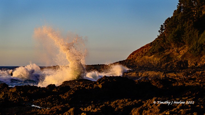
However, this viewpoint proved to be an excellent spot from which to set-up the tripod and camera, and then shoot away. The afternoon light was fairly even, so the photos came out pretty well. I really got into the scene, and I decided to stay until sunset. That afternoon light kept getting better.

The cool thing about going to Cape Perpetua area in January is that there were no crowds. I only saw two people on the trails, and never saw anyone else come down to the spit where I was set-up.

I waited for that perfect time when the sun is just about hitting the western horizon, and was rewarded with some wild sunset waves. This is a place that you really need to check out if you are on the Oregon Coast!

However, to really experience that perfect sunset moment, you need to watch this video below.
What an incredible afternoon and evening! I had this awesome place all to myself, and was able to set-up in a nice spot to catch some great views and wave action. I want to especially say thank you to my friend from Portland, Oregon, Cheryl, for recommending the drive down to the Cape Perpetua area, and Devil’s Churn.
I hope you enjoyed this story and the photos and videos about this special place on the Oregon Coast. Thank you for taking the time to visit my blog. Have fun and stay safe out there!


😎😁
You make the road by walking it.
Ben Macri
LikeLiked by 1 person
Looks lovely!
LikeLiked by 1 person