


Last year when I travelled to Kanab, Utah I had intended to do some hiking over near Page, Arizona as there are a number of slot canyons and lots of other fantastic scenery there. However, Mother Nature had other ideas as the western US was just coming out of an incredibly wet winter season. Everything in southern Utah and northern Arizona was wet – the slot canyons were skinny lakes. Right before I made the drive to Kanab, someone had died in one of the canyons near Page – they drowned in a slot canyon.
So, this spring I waited until early May hoping that the winter wetness had mostly abated. This year, Mother Nature was quite a bit more cooperative. Also, I was trying to coordinate this trip with a car show in Page. That may be the subject of another post.
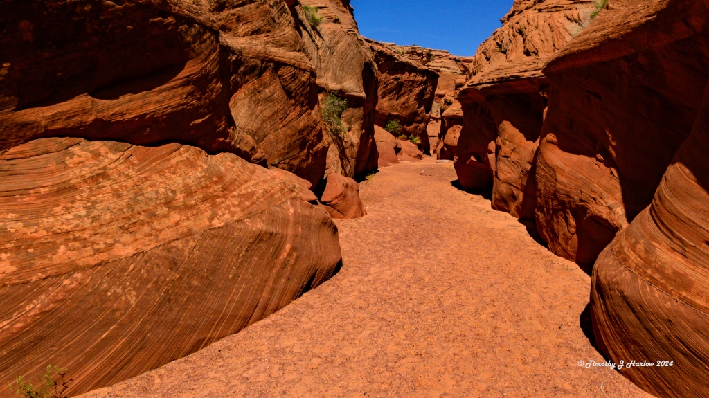
Waterhole Canyon
Anyway, my first hike was through a slot canyon known as the Waterhole Canyon on the Navajo Nation. This canyon is only a few miles south of Page on US Highway 89, and it is much less travelled that it’s more famous peers like Antelope Canyon. To enter the canyon, one must book a Navajo guide. There is a parking area with a guide station right next to US 89.

I got super lucky as there was an available guide in just under an hour, and there was only 1 other person booked on the tour. The hike into the canyon is pretty easy, but I can’t quite recall how many miles we hiked. One thing I would note regarding the hike was that the canyon gets really narrow in some spots (you must remove a medium size backpack to fit), and there are some metal ladders/stairs that you descend as you get deeper into the canyon. The weather was perfect that morning, in the high 60s Fahrenheit. The cool thing about the guide was the knowledge that he possessed, regarding both the local geography and geology as well as the Navajo culture.
Waterhole Canyon trail winds around on the east side of US 89, and then crosses under the highway, eventually emptying into Colorado River. However, the hike is restricted to the canyon on the east side of the highway. Everything west of US 89 requires a special permit from the Navajo Nation, technical climbing gear and an an inspection of the gear prior to entering that portion of the canyon.

This was now my second guided trip on the Navajo Nation – the first was in mid March in Monument Valley. So, here are my overall impressions of the guided tours. Both guides I had were awesome folks – friendly, knowledgeable, polite and well trained. If you want to learn about the area, that is the way to go. I would say that the one downside common to both tours was that if you are a serious photographer, the photo opportunities are quite limited. I surmise that is simply because of the schedules the tour guides must keep.
I am one of those people who can take an hour or more hiking a half mile if the photo opportunities are there. In this case, the only way to access the canyon was via the tour. Much of the land in this part of the Southwestern US is on the Navajo Nation. From what both guides had told me, the Navajo used to just let people go hiking in these areas unaccompanied. However, over the years many problems arose. The biggest issues were vandalism, theft and trash left by the hikers.

The Navajo and their ancestors have lived in these lands since ancient times. Many of these places are sacred to the Navajo people, and many places contain ancient art as well. It doesn’t take much research to learn about the preponderance of ancient artifact theft and vandalism in the US Southwest. So, around the time of Covid, the tribal councils decided to close off much of the areas to the general, non-Navajo public. Thus, they now have us enter these areas with guides.
So, one thing that I would like to state again is that, when visiting these lands please remember that we are guests here. This is no different that visiting a country foreign to you. You are a guest; be respectful of the culture, people and heritage as well as the natural environment.

Cathedral Wash near Marble Canyon
As I don’t get down to the northern Arizona/southern Utah area too often, I decided to do another hike down south of Page near an area known as Marble Canyon. Marble Canyon is on the Colorado River, east of where the Grand Canyon begins. This area is either managed by the National Park service or the BLM (Bureau of Land Management, a federal agency). The hike I chose was the Cathedral Wash trail that ends at the Colorado River. (This trail was also closed last year.) The hike starts easy enough – it begins in a narrow wash and goes through a tunnel type bridge under the road to Lee’s Ferry. (Next time I am going Lee’s Ferry a bit more north on the Colorado River. Could be an interesting place.)
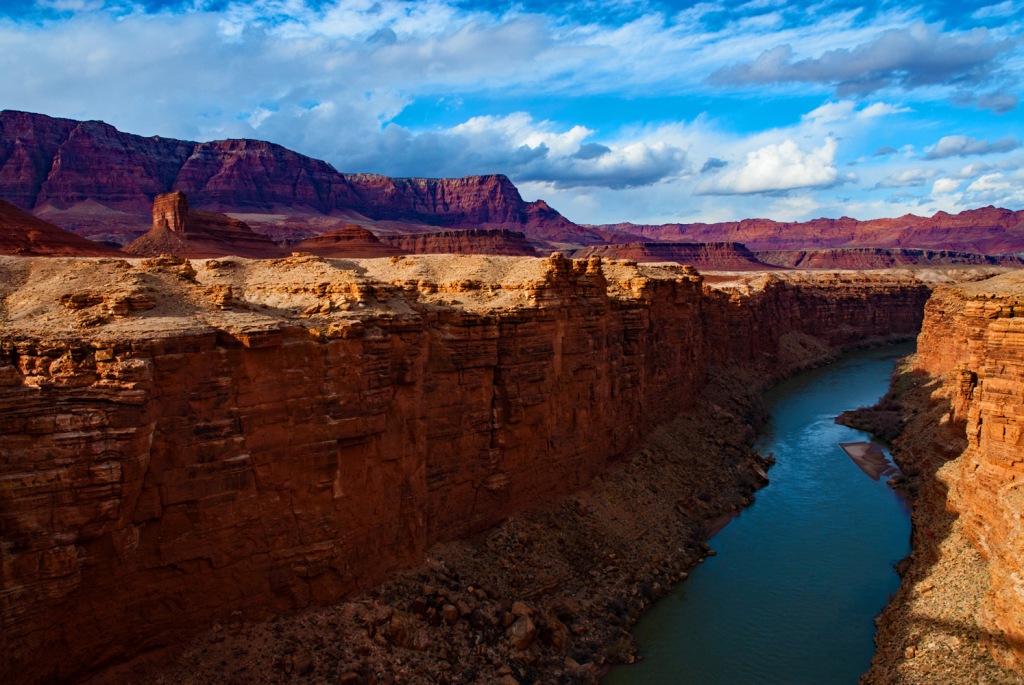


The trail follows the dry (this year) river bed, slowly winding downward toward the Colorado River. Do not be fooled by the extremely easy start of this hike. It starts out as a casual walk, and then gets progressively harder as you wind downward deeper into the canyon. I ended up having to do quite a bit of rock scrambling and some non-technical climbing, and finally reached a point where I felt it was no longer safe to pursue by myself. No, I did not make it to the Colorado. (Mother Nature 1, Tim 0.) But that’s ok. The scenery was great, and in early May the trail wasn’t crowded.


Horseshoe Bend – Colorado River
The last hike was a side trip over to Horseshoe Bend just about two miles south of Page on US 89. The park is actually administered by Page, and there is a $10 charge per car for parking. The trail to the bend of the Colorado River is short – only about 3/4 of a mile (1.2 km). The trail is a wide gravel path that is suitable for just about everyone. There are even a couple of shade shelters along the way. (It’s a stretch calling it a “hike”)
I think I made a mistake on my timing for his hike. My idea was to get up early and catch the first sun over the Colorado River as the view faces east – away from the sun. That usually makes for better photos, especially if there is any haze as there often is in the desert southwest once the heat starts to build. Well, when I got to the Bend overlook, almost everything was still in deep shade, except for the top most portion of the canyon walls.
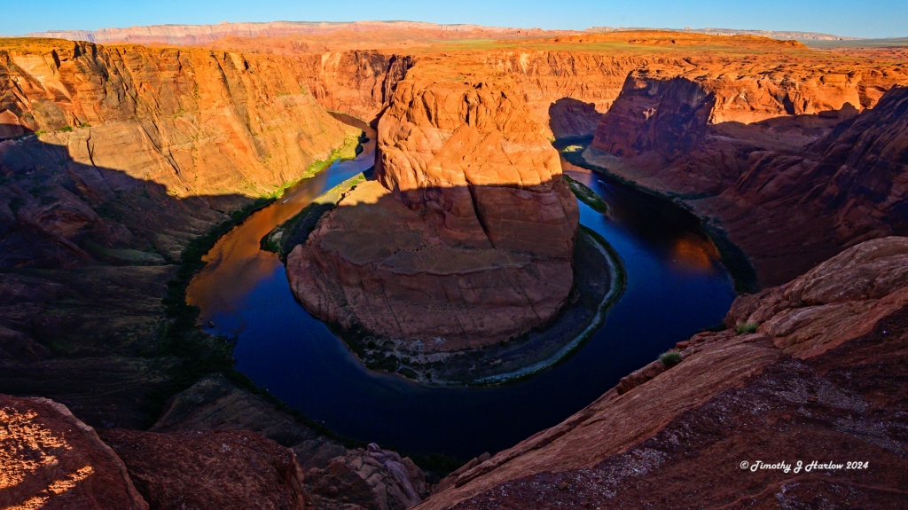
The crowds were also building at the overlook point, so I ventured off toward the south along the bend walls to find some more photo opportunities.

One thing I’ve learned over the years while hiking in crowded, popular areas is this – don’t just take the same shot everyone else does. Get off the beaten path; search for more photos. Most folks never get away from the main trail, nor do they ever look around, away from the “view”. Take time to “get into” the place where you are. I had a photography teacher in college, John Telford, who gave me a great piece of advice.

One time while were were on a week long photo workshop, he had us just find a peaceful spot and instructed us to just sit quietly in the spot for an hour taking in the essence of the area. His goal for for us was to become more integrated into our area before snapping the shutter.


This is why I often hike alone – to get myself in the right mind and be in “the zone”. It’s my opinion that to really “see”, one must get into sync with one’s surroundings.

So, this about wraps up my trip to the Page area. This is a place that I must return as there is nearly an infinite amount to see and explore in the area. And if you get off of US 89, and go into town, Page has some excellent restaurants and a really nice brew pub called the Grand Canyon Brewery. They have great food, good beers, shaded afternoon patio seating and lots of good company.

I hope you enjoy the Page area tour as much as I did. Spring is a nice time to visit. There are less crowds, the temperatures make for nice hiking, and sometimes you get a spring rain to clear the sky and freshen things up a bit.
If you do chose to hike in the areas around Page, please remember that the southwest desert is a harsh environment. Bring lots of water, more than you’ll think you need. Bring sunscreen and sun protective clothing. (I always bring a hat with good ventilation and a wide brim.) Follow the guide’s advice, or the advice of the Park Service, etc. – it’s for your own protection. And if you are going to the backcountry, wear good shoes or boots and be snake aware. This is rattlesnake country.
Thanks so much for visiting my blog. I’d love to know what you think, and answer questions if you have any. Wishing everyone the best!


Nice story! It’s hard to proof read your own work. 🤭😉 You make the road by walking it.
Ben Macri
LikeLiked by 1 person
what an amazing landscape. My sister came here a few years back, she said it was like a different world to anything we have in Europe.
LikeLiked by 1 person
Thank you! I cannot say, but the American
southwest definitely has a unique history and geology.
LikeLike